Cyclone Michuang batters South India, a stark reminder of climate change impacts
The warming oceans along with the El Nino phenomenon and other two important oceanic phenomena, the Indian Ocean Dipole and Madden-Julian Oscillation, are also responsible for the rapid intensification of cyclones that is triggering the heavy rain
By Kartiki Negi / Dec 5, 2023
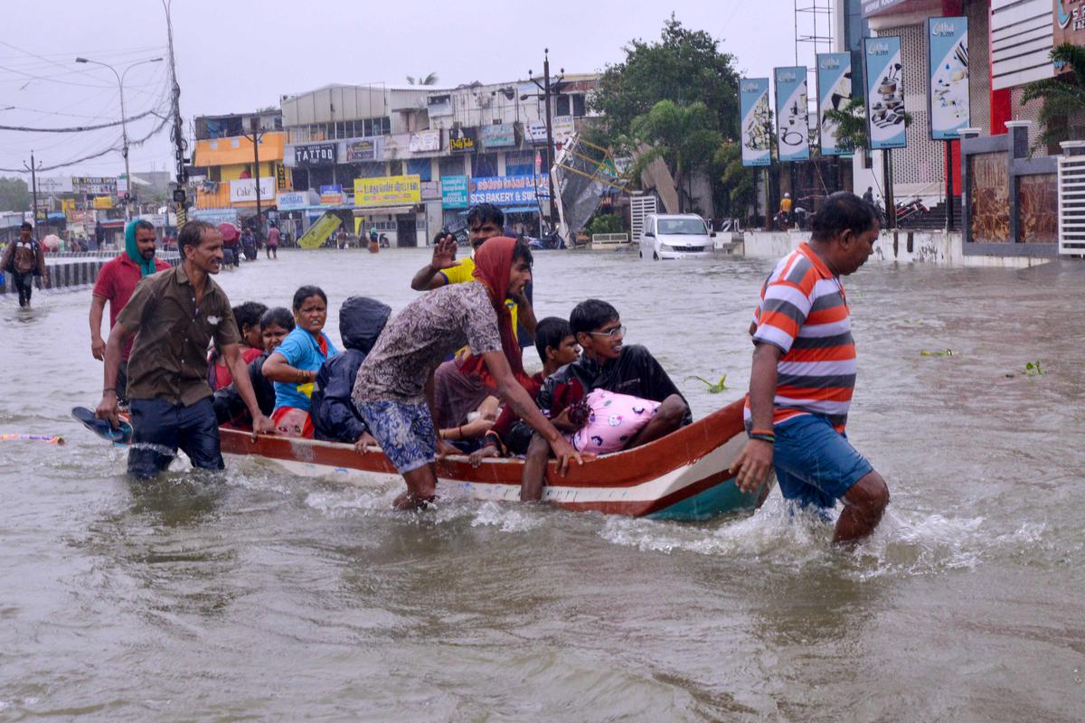
Image Courtesy: The Hindu
Severe Cyclone Michuang over the Bay of Bengal wreaked havoc as unprecedented rainfall triggered flash flooding across the coastal parts of North Tamil Nadu and adjoining South Andhra Pradesh since December 3.
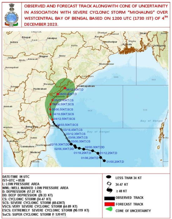
Michuang made landfall close to south of Baptla, Andhra Pradesh on December 5 2023 as a Severe Cyclonic Storm with maximum sustained wind speed of 90-100 kmph. The system will now move northwards on land, parallel to the coast. With this, it is still close to the Bay of Bengal, which continues to infuse moisture into the system. This has helped Cyclone Michuang sustain its strength for a few hours after hitting the coast. However, even as a weakened depression and low-pressure area, moderate to heavy rains, accompanied by squally winds, are expected over Andhra Pradesh, Telangana, and Odisha in the next few days.
Cyclone formation is normal, but rain intensity indicates the opposite
Michuang is the sixth storm of this year in the Indian Seas. December is the peak month of the post-monsoon cyclone season, where most of the cyclonic storms usually head towards Tamil Nadu and South Andhra Pradesh. While the formation of a tropical storm in the Bay of Bengal during December is very timely, the intensity of rains associated with the cyclone Michuang is not normal.
The frequency and intensity of cyclones have increased manifolds, courtesy of global warming. 93% of the heat is being observed by the oceans, and warm waters act as an energy source for cyclones. Scientists note that the intensity of the cyclone depends not only on sea surface temperature but, more importantly, on the volume of warm water in the ocean.
According to a report, the increase in sea surface temperature could result in peak heavy rainfall (>65 mm day−1) in the Tropical Cyclone inner-core region, especially the rear sector. Heavy rainfall areas extend to greater distances (>300 km) around the tropical cyclone centre with SST warming. The observed changes of tangential wind speed due to large sea surface enthalpy fluxes (rate of flow of heat energy) associated with ocean warming result in Tropical Cyclone size changes and then guide the cyclone to north-eastward movement.
Similar conditions were seen in Chennai, which saw incessant rains on December 3-4 as the dense cloud bands of cyclone Michuang hovered over the city.
The trio of El Nino, IOD and MJO
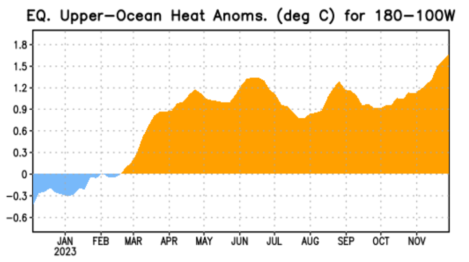
El Nino, since the very beginning, has been in the news for its rapid intensification. Equatorial sea surface temperatures (SSTs) are above average across the central and eastern Pacific Ocean. Nino 3.4, the representative of ONI (Oceanic Nino Index), has crossed 2°C for the first time since February 2016, after the super El Nino of 2015. Chennai recorded 292 mm of rain on December 2, 2015 (An all-time high record).
El Niño is characterised by a positive ONI greater than or equal to +0.5ºC. However, these ONI thresholds must be exceeded for at least five consecutive overlapping 3-month seasons.
“El Niños usually peak around Christmas in December, a reason why they derive their name from the Spanish term for ‘little boy’. As oceans absorb more than 93% of the additional heat from global warming, El Niños are also getting stronger. They are not little boys anymore but monsters of the sea. Changes in ocean-cyclone interactions have emerged in recent decades in response to Indian Ocean warming and are to be closely monitored with improved observations since future climate projections demonstrate continued warming of the Indian Ocean at a rapid pace along with an increase in the intensity of cyclones in this basin,” said Dr Roxy Mathew Koll, Climate Scientist at the Indian Institute of Tropical Meteorology.
Meanwhile, two other important oceanic phenomena, the Indian Ocean Dipole and Madden-Julian Oscillation, both associated with positive rainfall over Indian landmass, were in favourable zones. These, along with anomalous high sea surface temperatures, provided conducive dynamic and thermodynamic conditions for the genesis.
How global warming is changing the dynamics of cyclones for India
Role of SST in the intensification of cyclones: Recent observations indicate that cyclones in the north Indian Ocean are now exhibiting rapid intensification, intensifying by more than 50 knots in just 24 hours, in response to SSTs much higher than 30°C, prominently due to the rapid warming in the region. From 2000 onwards, the frequency of cyclones undergoing rapid intensification in the north Indian Ocean has increased. The percentage of cyclones undergoing rapid intensification in the north Indian Ocean is higher (38%) than the cyclones in the northwest Pacific Ocean, where this rate is 22%. Due to the eastward shift of the cyclogenesis location in the Bay of Bengal, the cyclones are now travelling for a long time over the ocean and drawing more of the thermal energy released from the warm ocean waters, thereby enhancing the chances of developing into a very severe cyclone with intensity greater than 65 knots.
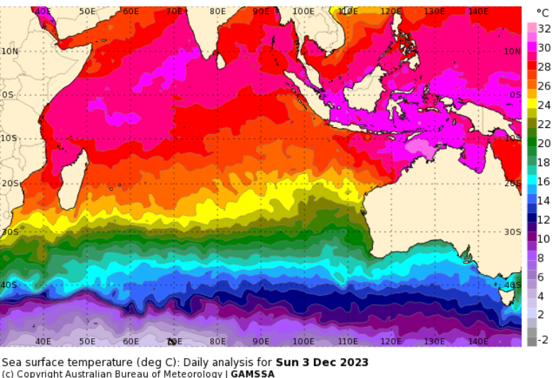
Ocean Heat Content: Besides the SST, the ocean heat content also regulates the TC intensity, particularly for slowly moving TCs. The intensity of cyclones in the north Indian Ocean is governed not only by the SSTs but also by the high ocean heat content and warm ocean subsurface. Ocean heat content acts as an essential parameter governing the life cycle and intensity of cyclones in the north Indian Ocean. High ocean heat content implies a warmer upper ocean, which helps cyclones sustain or intensify due to the uninterrupted supply of sensible and latent heat fluxes from the ocean surface to the atmosphere.
Rapid global temperature increase has made cyclone forecasting further challenging. According to scientists, it is vital to garner critical information associated with ocean warming to assess the cyclone impact and management and to develop a cyclone-resilient society.
Cyclone Michuang Cyclone in Bay of Bengal Cyclone In India Climate change and cylone Michuang