Himalayan infra, and an avalanche of problems
Following Sunday’s flash floods that has left an under-construction NTPC hydropower plant decimated, India’s plans to continue high-altitude hydropower development are once again under the scanner.
By Shreeshan V / Feb 12, 2021
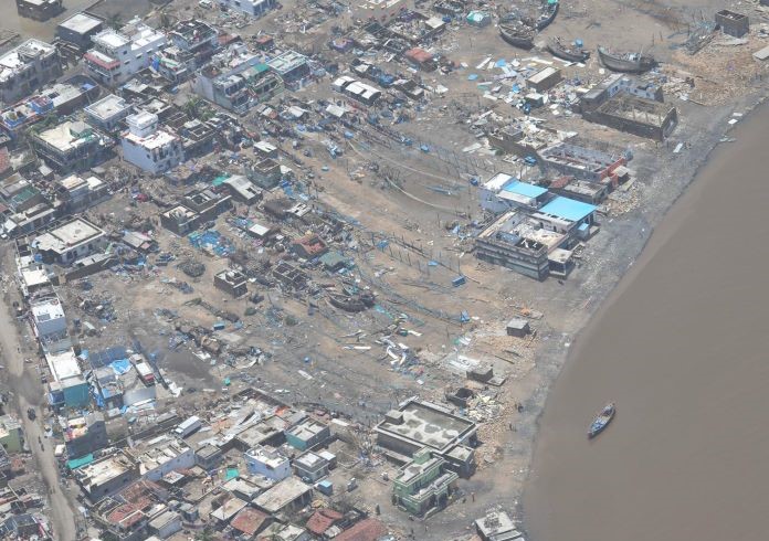
Destructive potential: An aerial view of the destroyed Tapovan-Vishnugad in Uttarakhand's Chamoli after Sunday's flash flood | Photo: Twitter/Maxar
On February 7, television channels and mobile devices were inundated with dramatic images of a flash flood caused by a possible glacier collapse in the Chamoli district of Uttarakhand. A swollen Dhauli Ganga river gave way, causing massive destruction, killing 37 people (at the time of publishing, with 168 people still missing) and washing away the under-construction Tapovan-Vishnugad hydropower project. Rescue operations continue to search for missing people, who had mere seconds to run to safety. But was this just another glacier break considered commonplace in high mountainous regions or were we witness to the wrath of climate change, as suggested by many experts?
Trigger theories
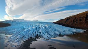
Scientists are currently piecing together the trigger for the flash flood. Preliminary evidence and satellite images suggest that the sudden increase in the river’s discharge was caused by an avalanche following heavy snowfall near the feeding glacier in the Nandadevi mountain range at an elevation of around 5,000 metres. The mass movement of rock and ice, in turn, caused a glacial overhang near the snout (called a hanging glacier) to collapse into the river around 2,000 metres below, say experts studying the incident.
“Our initial assessments and satellite images suggest the flash flood was triggered by ice-rock fall in the higher altitudes of the range. Currently, it looks like a hanging glacier broke off near the snout of the main glacier and had a free fall into the valley, causing the surge in flow. However, questions regarding the increased volume of water still remain,” explains Mohd Farooq Azam, assistant professor of Glaciology and Hydrology at IIT Indore. The most probable explanation for this, adds Azam, is an accumulation of melt water from heavy snowfall in January and early February that had collected in a small pond, which was breached as the rock and ice from the hanging glacier crashed into the valley.
A separate analysis conducted at IISc indicates the release of water from an underground glacial lake led to the flash flood. The team based its conclusion on images that suggest a 25 hectare depression in the bedrock near glacial ice in northern Nanda Devi, which is part of the Garhwal Himalayas in Chamoli district. New satellite imagery, however, also points to the possibility that the flash flood was a result of fresh snow falling off the mountain, resulting in an avalanche that is estimated to have released 3-4 million cubic metres of water in the surrounding rivers.
Latest images show a new lake forming due to accumulated debris in the river from Sunday’s incident, setting off fears of the possibility of a second surge in the river.
Is there a climate change link?
While such occurrences are fairly commonplace and natural in high mountain environments, experts feel the imprints of climate change are clear. “Such breakages in hanging glaciers happen a lot in high mountains as overhangs snap periodically under heavy ice loads. However, it is also clear now that the warmer winters being experienced in recent years have negatively impacted the stability of such formations. This could have been an added factor in the recent incident,” says Azam.
The Himalayas still represent one of the largest gaps in knowledge when it comes to studying climate change and its implications. However, increased research interest over the past decade has slowly revealed worrying changes in the region, which has been experiencing above average rates of warming over the past 50 years. The largest and most comprehensive assessment yet of the Hindu Kush Himalayas (HKH), published in early 2019 by the International Centre for Integrated Mountain Development (ICIMOD), found that rates of warming in the HKH region were not only higher, but would continue well into the 21st century even if global warming was limited to 1.5°C. The report also noted that increasing temperature had meant that while extreme cold events were on the decline, extreme warm weather events have become more pronounced. Recent research has not only estimated alarming rates of glacier retreat and reductions in glaciated area in the Himalayan region, it has also revealed rapid fragmentation of glaciers.
The dangers of glacier melt
“With increasing global warming, the upper reaches of the Himalayas are warming faster, leading to more rapid melting of the glaciers. This has resulted in an increasing number of glacier lakes, which are formed by water melting from the ice caps and accumulating at the mouth or snout of the glacier. These lakes also become reservoirs of ice and moraine debris. With an increase in this phenomenon, the breach of glacier lakes poses a severe threat to the communities living downstream,” says AP Dimri, a professor at the School of Environmental Science at Jawaharlal Nehru University.
Glacier melt is a complex process that culminates from not only surface temperatures and meteorology, but also topography, debris cover, depth of ice, bedrock slopes, just to name a few factors. Worryingly, smaller glaciers melt faster than larger ones. The fragmentation of the Himalaya’s glaciated sections implies further acceleration of glacier melt.
Further complicating matters, the loss in glacier ice mass has translated to rapid proliferation of glacier lakes formed from accumulating melt water held back by naturally formed rock and ice walls. According to remote sensing data, there are over 25,600 glacial lakes formed due to meltwater from glaciers across the HKH, covering an area of 1,414 sqkm. Research on these lake formations, especially following the 2013 Kedarnath tragedy, have increasingly warned of the progressively worsening risks posed by the growing number of lakes. The high seismicity of the Himalayan region amplifies the risks of glacial lake dam walls breaching and downstream flash flooding.
“There are currently no conclusive causal links between Sunday’s flash flood and the construction downstream. However, it does indicate heightened risks for such projects, which requires a holistic rethink of our planning approach. Big glacial lakes pose a major threat, but it is highly probable that relatively smaller incidents triggered by glacial instability will also increase in the future with potentially devastating consequences,” expounds Azam.
Backing a fragile nexus
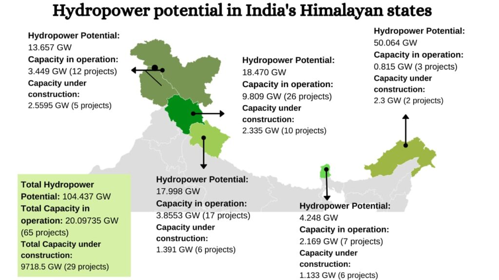
The Himalayan glacier network is responsible for feeding massive perennial river systems in South Asia, which include the Ganga, Brahmaputra and Indus river basins. Apart from the water flowing through these systems, the glaciers represent huge energy generation potential. According to official assessments published by the ministry of power, India’s Himalayan states carry over 104 GW of hydro power potential, of which only about 20 GW have been currently tapped. This massive potential has meant that despite the expanding recognition of the dangers posed by the volatility in the Himalayan ecosystem, India has continued to grow the number of high altitude hydropower projects.
The bad reputation garnered by large dams for mass displacement and pronounced environmental impacts led to the drying up of international finance for such projects in the 1990s. This, accompanied by the privatisation of hydro power in India, led to a pivot in India’s energy planning strategy.
While the 1995 Mega Power Policy paved the way for private investment hydro power, the 50,000 MW Hydro Initiative launched in 2003 started the image makeover of hydro power as a sustainable source of renewable energy. Rather than large earth dams that required enormous amounts of capital, the government decided to tap the energy potential through smaller projects situated higher up in the mountains. In the two decades since, small hydro projects, fed through tunnels bored into mountain ranges have cropped up across all of India’s Himalayan states. With private investments in sight, India’s policy framework for hydropower promoted progressive deregulation of the renewable energy market, minimal state interventions, and relaxations in clearance procedures. Importantly, state governments were given the power to allot and commission projects independently.
Currently, more than 20 GW of hydro power split over 65 projects are in operation across Himalayan states, with Himachal Pradesh representing nearly half of this capacity. A further 29 projects, with a capacity of 9.7 GW, are currently being constructed despite rising evidence of the risks posed by land use change in the region.
The Kedarnath aftermath
Following the devastating 2013 Kedarnath flash floods, the Supreme Court appointed an Expert Appraisal Committee to look into the viability of 24 hydroelectric projects flagged by the Wildlife Institute of India (WII) as having significant impacts on the ecosystems of the Alaknanda and Bhagirathi basins. The committee looked into the 24 projects planned at elevations of more than 2,500 metres and recommended an immediate stoppage to 23 of the projects. The committee further recommended a review of all the under-construction and proposed hydro power projects, which entail tunnelling, formation of a barrage or a reservoir.
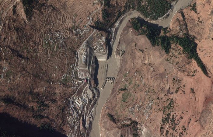
National Thermal Power Corporation’s (NTPC) Tapovan-Vishnugad hydropower project, situated at an altitude of about 1,700 metres, which was all but washed away in Sunday’s flash flood, exemplifies the current underestimation of risks associated with high altitude development projects. The Tapovan-Vishnugad HPP, which was not planned to handle sudden surges in river flow, was not equipped with any early warning systems. This means there was practically no advance warning of the flood. Similar incidents over the past few years reported from Himachal Pradesh and Sikkim show that the under-preparation and poor planning reflected in Sunday’s incident is chronic rather than exceptional.
According to CarbonCopy’s analysis of hydropower project details updated by the Central Electricity Authority in December 2020, projects with over 15 GW of generating capacity currently operate or are currently being built at a height of over 1,500 metres, making them particularly vulnerable to extreme weather and changes in glacier dynamic further upstream.
A matter of unbalanced risks
The increasing number of accidents associated with infrastructure development in the Himalayan region has not gone unnoticed by locals directly affected by the projects. Sunday’s disaster in Chamoli might have been the tipping point of public opinion when it comes to high-altitude hydropower projects. Residents from at least two panchayats in Himachal Pradesh’s Lahaul-Spiti district have now raised demands to scrap planned projects in the district. Closer to the site of the latest incident, residents of Pipalkoti in Uttarakhand have intensified their protests against blasting and tunnelling work being done for THDC’s Vishnugad-Pipalkoti hydro electric project. Similar protests by locals in Sikkim and Arunachal Pradesh against planned and under-construction hydro electric projects have been reported over the past few years.
India’s Hydropower Policy of 2008, the directive document for India’s hydropower planning, is replete with concessions and exemptions, which insulate operating entities from most of the risks inherent in the sector. These risks, experts have argued, have been shifted onto the public, while margins of profits are maximised. Guaranteed payments for “design generation” and tariff regimes further nullify any incentive to optimise and upgrade designs more in line with environmental thresholds and projected changes.
Studies looking into India’s hydropower development also point out that joint ventures often used to implement projects “reduce the distance between project regulators and implementers.” This has led to compromises in environmental assessment impacts (EIAs), which often exhibit proof of sanitisation by developers to remove problematic aspects.
“Planning and implementing large engineering projects on himalayan rivers is fraught with great risks. Most scholars of Himalayan rivers have been warning about these risks for decades, but the EIA for these projects withhold or underplay this information so that projects get approved. Given that climate change is such a complex phenomenon and is affecting everything in our environments, development and environmental policies should really not be selecting these options that put people at great risk,” says Manju Menon a senior fellow working on climate policy and environmental justice at the Centre for Policy Research.
Provisions made to attract investments currently have culminated in an unequal balance of the risks associated. This in turn has led to India’s hydro-power fleet being grossly misaligned with not only ecological sustainability of projects, but also their capacity to withstand impacts of environmental changes. This issue of unbalanced risks is not only a problem for the hydropower sector, but extends across infrastructure projects.
What India currently needs is a thorough reassessment of its policy and plan regarding hydropower and other infrastructure development to not only gauge the impact of the project, but also their adaptive capacity. Sustainable, after all, is no longer simply a matter of environment-friendliness in design, but also includes the ability to absorb and insulate against impending changes in the Himalayan region.