June gets 10% deficit Monsoon rains; heavy rain in 377 stations, highest in 5 yrs
The onset month of the Monsoon season, June, ended with deficit rainfall to the tune of 10% of the LPA (Long Period Average). The countrywide cumulative rainfall during June 1-30 was recorded at 148.6 mm against the normal average of 165.3 mm.
By Editorial Team / Jul 1, 2023
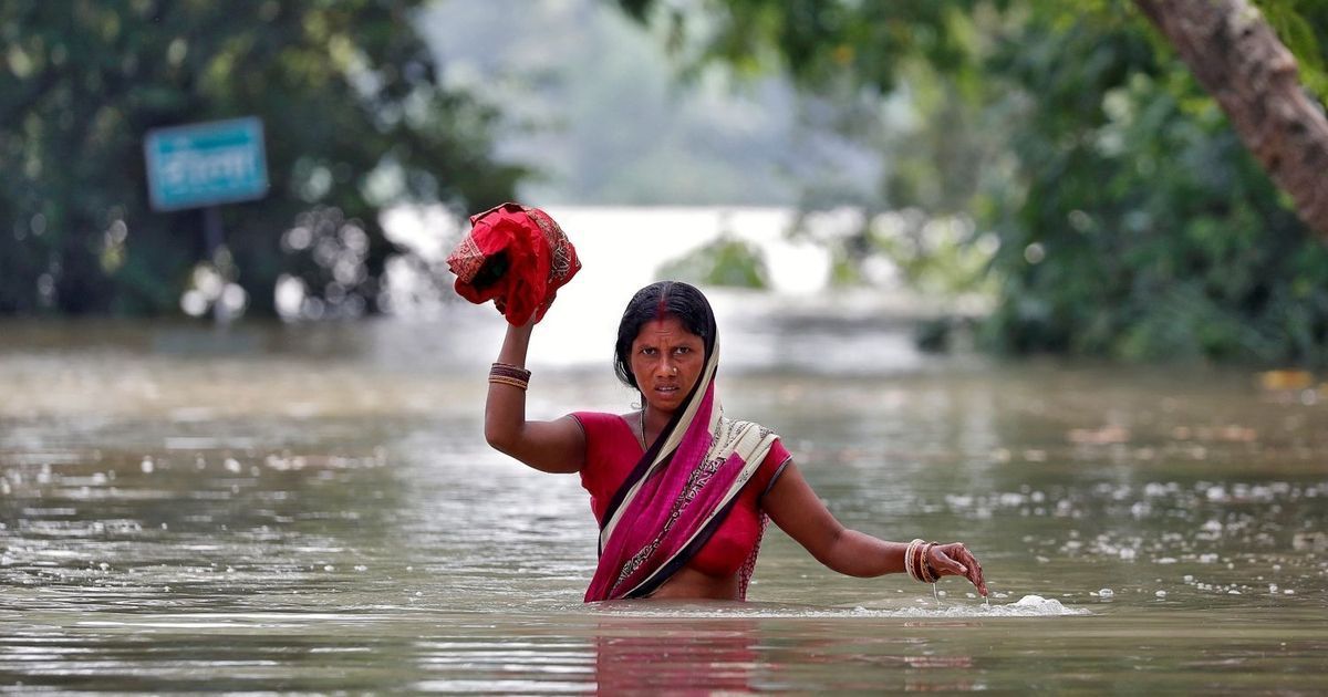
Image Courtesy: Scroll.in
The onset month of the Monsoon season, June, ended with deficit rainfall to the tune of 10% of the LPA (Long Period Average). The countrywide cumulative rainfall during June 1-30 was recorded at 148.6 mm against the normal average of 165.3 mm.
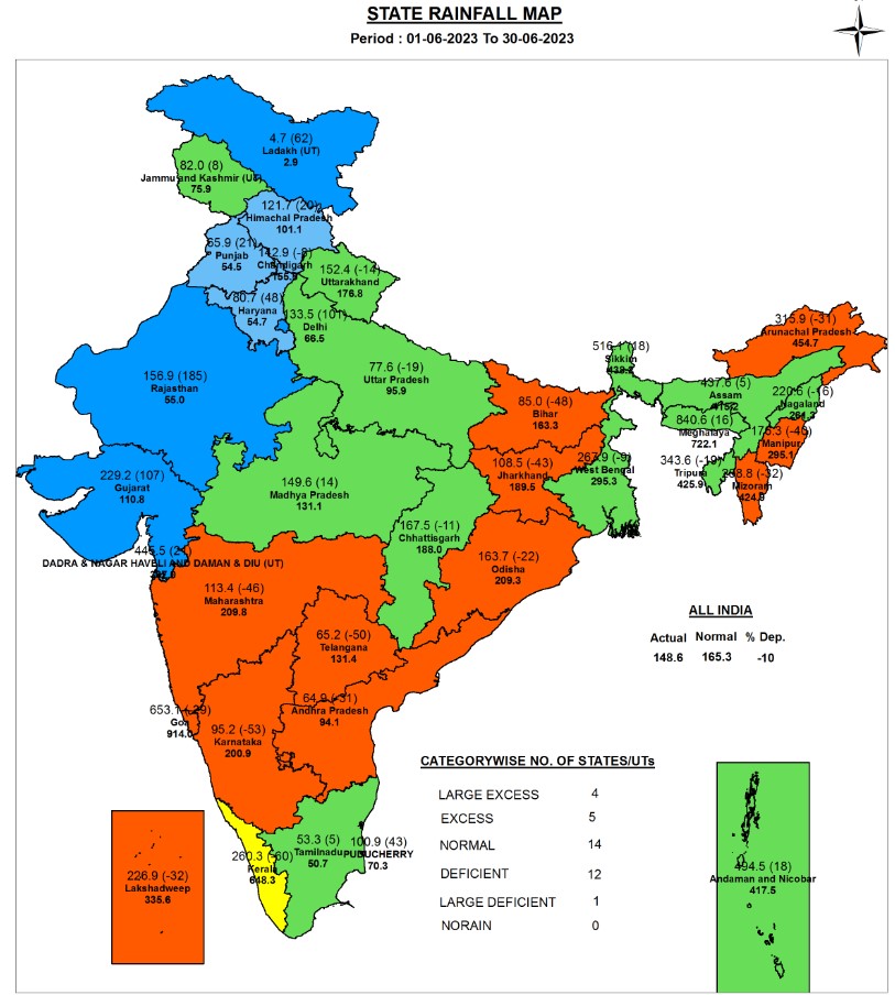
Out of the four meteorological sub-divisions, Northwest India was the only region to record excess rainfall. Rest all the regions have recorded deficit rainfall in order of South Peninsula, followed by East and Northeast India and Central India.

Data Source: IMD
The country’s nodal weather agency, India Meteorological Department (IMD) in their earlier forecast had predicted below-normal rainfall is expected over most parts of the country.
Onset, progress, and performance of Monsoon 2023
Monsoon had made a delayed as well as subdued onset over the Indian landmass. Thereafter, the progress of the Monsoon was also not very promising, as there was a delay in the advancement of the Monsoon over the Peninsula and adjoining central India by 7-12 days and Northeast India by 5 days. However, the Monsoon current made an early onset over northwestern parts of the country, covering most of the country by June 28.
Above-normal Monsoon rainfall was recorded over many parts of Northwest and Northeast India, and a few parts of the southern region.
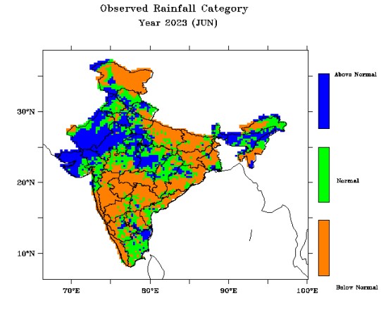
The extremely severe cyclonic storm Biparjoy had a long run in the Arabian Sea from June 6-19. It helped in advance of monsoon during the initial stage, bringing heavy rainfall over Gujarat, Rajasthan, Madhya Pradesh, and adjoining Uttar Pradesh. However, the system took moisture away from the rest of the country, leading to deficit rainfall. Until June 23, the rainfall deficit was 31%.
It was only after Biparjoy weakened, there was the formation of weather systems in the Bay of Bengal that drove the Monsoon subsequently. Two low-pressure systems (LPS) over the north Bay of Bengal on June 9 and June 25 helped in advance of monsoon and good rainfall activity.
Out of 36 sub-divisions in the country, 17 recorded deficit rainfall, 2 large deficit, 7 normal, and 7 excess. Only three subdivisions- Saurashtra & Kutch (196%), West Rajasthan (287%) and East Rajasthan (118%) recorded large excess rainfall. These heavy rains were on account of Cyclone Biparjoy, which had made landfall over the Gujarat coast and moved across Rajasthan.
Meanwhile, MJO (Madian Julian Oscillation), an oceanic phenomenon that favours rainfall over India, was also in a favourable phase, aiding the rainfall.
Extreme Weather Events
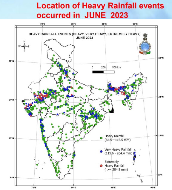
Rainfall: 377 stations across the country reported very heavy rain events, the highest in the last five years. Meanwhile, 62 stations recorded extremely heavy rains which was the second highest since 2019. Following are the number of stations that recorded heavy to extremely heavy rains from 2019-2023.

Data Source: IMD
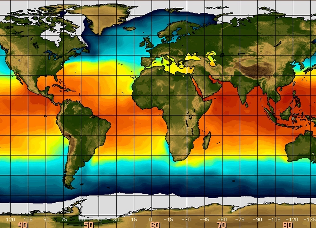
Heatwave: Delayed Monsoon conditions led to heatwave to severe heatwave conditions over several parts of East India and adjoining parts of Central India during the month. Above Normal Heat Wave Days were observed over West Bengal, Odisha, Coastal Andhra Pradesh, Bihar, Jharkhand, Chhattisgarh and adjoining parts of East Madhya Pradesh, Vidarbha & Telangana.
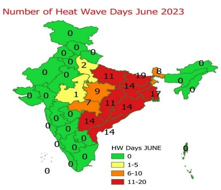
Image Source: IMD
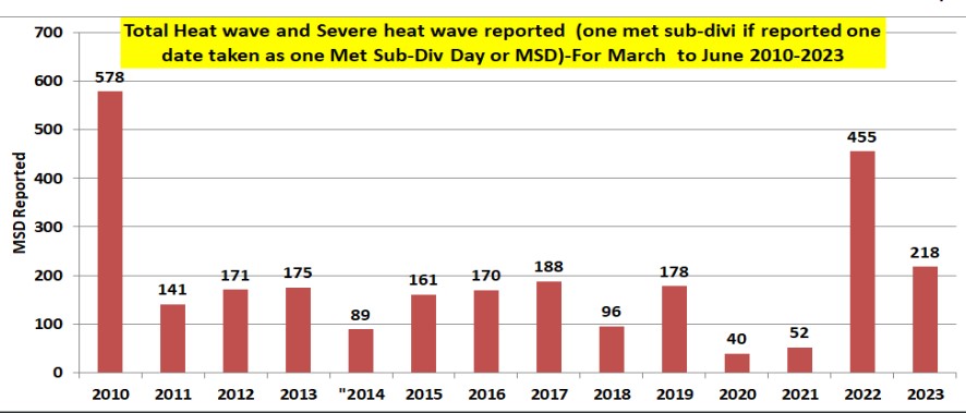
Total Heat wave and Severe heat wave reported in summer of March-June 2023 was 218 Met-Subdivision Days (MSD). It was 3rd highest during the last 23- years after 2019 with 578 MSD and 2022 with 455 MSD.
