The impact of changing patterns of Western Disturbances and La Niña on warmer winters
According to meteorologists, the anomaly in the temperatures and rainfall is the result of alterations in the weather patterns. The intensity as well as frequency of Western Disturbances have been on the lower side this winter season.
By Kartiki Negi / Mar 1, 2023
Image Credit: The Tribune
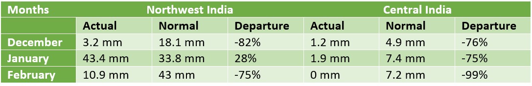
It was a mild start to the winter season this year, with November and December not recording any significant winter rains and snow. As a result, maximum temperatures settled well above the normal average. In fact, December 2022 was declared as the warmest in the history of 122 years, with the highest mean temperature to the tune of 21.49°C, after the earlier record of 21.46°C in 2008. The present temperature was one degree above normal that stands at 20.49°C for the month.
Meanwhile, January began on a brighter note, with some good spells of snow and rainfall across Western Himalayas. This also led to spells of cold waves across the Indo-Gangetic plains. However, February followed the same route as December, which again made it to the record list. The month was declared hottest, with the highest average maximum temperature since 1901, when IMD first started collecting data. Below are the average maximum temperatures recorded across the country for the winter months.
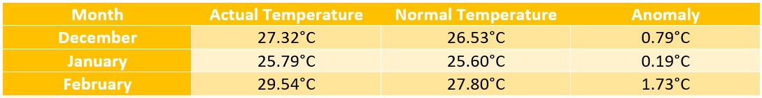
Data Source: IMD
The ongoing trend of above normal maximum temperatures can be attributed to the country’s deficit rainfall that has been recorded for consecutive four months. Winter rains have been largely evading Northwest, Central and East and Northeast India. The South Peninsula has been recording some rains on account of few low-pressure areas and depressions forming in the South Bay of Bengal, but their impact was confined to southern parts only. Following is the countrywide cumulative rainfall:
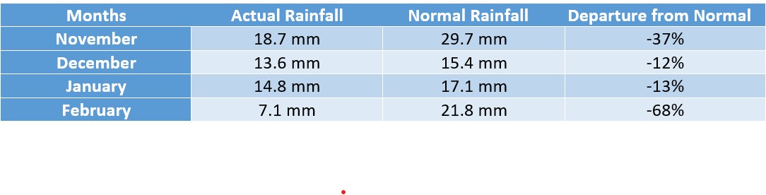
Data Source: IMD
The major contribution in the countrywide deficiency during the core winter months came from Central India and Northwest India. Both the regions were highly deficit from December-February. However, January saw some respite on behalf of some good spells across hilly states of Jammu and Kashmir, Himachal Pradesh, and Uttarakhand.
Data Source: IMD
According to meteorologists, the anomaly in the temperatures and rainfall is the result of alterations in the weather patterns. The intensity as well as frequency of Western Disturbances have been on the lower side this winter season. Western Disturbance is known to drive the weather activities and bring winters to Northwest India and adjoining areas of Central India. Although January saw a good number of active WDs, they could not have any impact on the weather across the Indo-Gangetic plains.
November: By mid-November, both the intensity as well as the frequency of Western Disturbances (WDs) start increasing across Western Himalayas. Besides, these bands of clouds also start moving in the lower latitudes, increasing the chances of precipitation. This month is also known as the transition month, allowing winters to seep in. Usually by the end of month, higher reaches of Himalayan states of Jammu and Kashmir, Himachal Pradesh, and Uttarakhand record one or two spells of moderate to heavy snow and rainfall. However, this was not the case during November 2022.
5 WDs moved across Western Himalayas, out of these, 2 WDs (2-5 and 6-9 Nov) caused isolated to scattered rain or snowfall over hilly states and adjoining foothills. Rest 3 WDs were feeble (13-15,18-21 and 22-24 Nov) and did not affect the region.
December: December started on a warmer note, with no rain and snowfall, winter chill kept evading the entire north western plains and adjoining parts of Central India. The month saw seven WDs, out of these, only 1 WD (28-30 Dec) caused rain or snowfall over Western Himalayas and adjoining plains areas. However, the remaining 6 WDs were feeble and did not affect the region significantly.
January: January started with a bang, with several WDs of moderate to active intensity making appearances at regular intervals. With this, Northwest India, especially the hilly states, recorded widespread rain and snow. As a result, the region ended with excess rains to the tune of 28%. However, with low intensity of any weather systems in the Bay of Bengal, the rains could not cover adjoining parts of Central India that continued with rain deficiency.
During January, a total of 7 WDs moved across the north Indian region. Out of these, 4 WDs (11-14 Jan, 18-21 Jan, 23-27 Jan and 27-30 Jan) caused rain or snowfall over Western Himalayan Region (WHR) and rainfall over adjoining plains. In fact, the last two WDs (23-27 Jan and 27-30 Jan) were active, causing isolated heavy rainfall and isolated hailstorms in Northwest India.
Meanwhile other 3 WDs (1-3, 3-5, 5-10 Jan) were feeble and moved away without significantly affecting the region, except isolated very light snow over the higher reaches of the region.
Passage of these WDs, was followed by chilly winds from ice capped Himalayas, triggering cold wave to severe cold wave conditions that prevailed during 1-9 Jan and 14-18 Jan 2023 over Northern and central Parts of India.
February: This month followed the pattern as in December, when there were back to back Western Disturbances but they were significant to give any precipitation over Northwest India. In fact, arrival of WDs in quick succession, blocked the chilly northerly winds from Himalayas from reaching the region. As a result, maximum temperatures continue to rise and settle well above normal average.
There is consensus among scientists and meteorologists over the fact that this is the era of climate change. According to a report by IPCC, the occurrence of extreme heat waves will very likely increase in Asia. Projections show that a sizable part of South Asia including India will experience heat stress conditions in the future. It is virtually certain that cold days and nights will become fewer.
Changing dynamics of Western Disturbances (WDs)
WDs are primarily disturbances originating in the west and travelling in the upper atmosphere in the subtropical westerly jet and arriving in the Indian sub-continent during the wintertime. Their frequency peaks during December to February, with an average number of 4-5 per month. In the course of their travel and evolution, they pick up a lot of moisture and character from the Atlantic Mediterranean Sea. When these disturbances travel through India, they merge with the mid tropospheric low which is existing over Indian western coast and get more intensified. With this, it gets more moisture from the Arabian Sea in addition to what it has picked up on its way. The interaction of WDs with the Himalayas have a huge role in orographic control (when moist air is lifted as it flows above a mountain range) in forming the precipitation mechanism.
However, increases in global mean temperature have changed the dynamics of these disturbances. The interplay of WDs with the topography of the western Himalayas determines the spatial and vertical distribution of precipitation. Hence, it becomes very important to read the role of climate change and its impact on WDs.
“In this changing world, WDs are showing distinct structural and dynamical changes. With global warming, WDs are getting lighter due to more convection and heat coming in. With this, they are tracking in the upper atmosphere. Besides, they have become more dynamic also. Off late, it is seen that all WDs do not precipitate. This means there are days when there is no precipitation happening during their passage and contradictorily there are non-WD days when good amounts of precipitation is seen over North India,” said Dr A P Dimri, Director, Indian Institute of Geomagnetism.
Dr Dimri further added, “Southern proposition of Northern Atlantic Oscillation (NAO) pushes the subtropical westerly jet further south, increasing the likelihood of a greater number of WDs. If reverse happens, there would be a smaller number of WDs. In the warming scenario, there will more stable atmosphere and global teleconnection, that will lead to weakening of WDs.”
“Above normal temperatures across the Arctic region due to global warming are a major cause of concern as it directly impacts the circulations affecting the Asia region. Warming in the Arctic region pushes air upwards leading to formation of low-pressure area, which attracts the circulations in the sub-polar region. This has been the case this season. The intensifying Arctic heatwave pulled up the weather systems including Western Disturbances northwards, making them travel in higher latitudes and thus, it did not affect the weather over India,” said Mahesh Palawat, Vice President – Meteorology and Climate Change, Skymet Weather.
According to research, since polar amplification means that the higher latitudes will warm faster than the Northern Hemisphere as a whole, the latitudinal temperature gradient will decrease, which should have an impact on total winter snowfall from WDs.
Polar amplification is the phenomenon that any change in the net radiation balance (for example greenhouse gas intensification) tends to produce a larger change in temperature near the poles than in the planetary average.
As per another study, It is clear that any significant changes to the frequency of WDs, intensity of WDs, or moisture flux associated with WDs will affect both the region’s precipitation climatology and extremes. The two future climate scenarios, RCP4.5 and RCP8.5, forecast a significant decline in WDs over the twenty-first century, both in the multi-model mean and the model interquartile range. By 2100, the projected declines in annual WD frequency for RCP4.5 and RCP8.5 are 6 and 9 yr−1 respectively.
A Representative Concentration Pathway (RCP) is a greenhouse gas concentration (not emissions) trajectory adopted by the IPCC. The pathways describe different climate future scenarios, all of which are considered possible depending on the volume of greenhouse gases (GHG) emitted in the years to come. RCP 4.5 scenario is described as a moderate scenario in which emissions peak around 2040 and then decline. RCP 8.5 is the highest baseline emissions scenario in which emissions continue to rise throughout the twenty-first century.
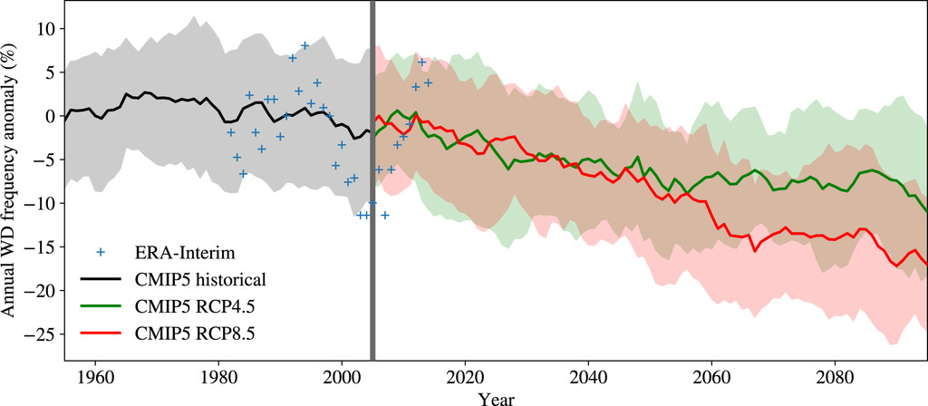
CMIP5 multimodel mean western disturbance frequencies by year: historical (black), RCP4.5 (green), and RCP8.5 (red). For comparison, ERA-Interim counts are given as blue plus signs. All data are smoothed with a 5-yr running mean and are shown as anomalies relative to a 1980–2000 baseline, computed for each model. Color-shaded regions indicate the intermodel interquartile ranges.
The above figure shows that a robust decline in western disturbance frequency is to be expected across all future climate scenarios, with greatest impact in the winter months. All future experiments (RCP2.6, RCP4.5, RCP6.0, RCP8.5) show a decline in annual WD frequency, of increasing magnitude with stronger radiative forcing in the more extreme RCPs.
We can see that winter precipitation in northern India and Pakistan is projected to decrease over the coming century due to the falling WD activity since they are responsible for the majority of winter precipitation in this region. In fact, mean winter precipitation over Pakistan and northern India is expected to decline (by around 10%–20%).
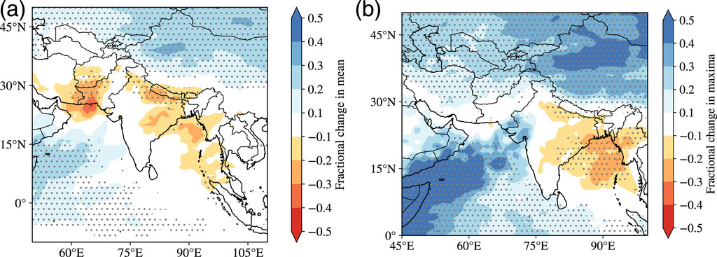
CMIP5 MMM fractional change to DJFM seasonal (a) mean precipitation and (b) maximum daily precipitation from 1980–2005 (historical) to 2075–2100 (RCP8.5). Stippling indicates where more than two-thirds of the models agree on the sign of the change.
Global warming defying oceanic phenomenon of La Niña
La Niña is defined as an oceanic-atmospheric phenomenon, El Niño-Southern Oscillation (ENSO), wherein water temperatures in the Equatorial Pacific Ocean become cooler than normal because of the upwelling of cold water from the bottom of the sea. La Niña has the capacity to alter direction as well as velocity of the trade winds, which trigger the winter season in India.
World witnessed prolonged stay of La Niña conditions, which is presently in its third year. The occurrence of three consecutive La Niña in the Northern Hemisphere is a relatively rare phenomena and is known as ‘triple dip’ La Niña.
La Niña has an association with winter rains over North India. Unlike El Niño, it may not have a strong correlation with seasonal features but remains consequential for the seasonal performance. Though there is no rule book for La Niña’s behavioural patterns, the performance for winter rains is expected on the following lines:
· Winter rainfall less than normal over North India
· Snowfall over Western Himalayas less than normal
· Winter temperatures in the plains to be less than normal
· Prolonged Winter Season over North India (extended winters)
However, what we witnessed this season was quite surprising. Despite persistence of La Niña, 2021 and 2022 were listed amongst record hot years. As per World Meteorological Organisation (WMO), the past eight years (2015-2022) were the warmest on record globally, fuelled by ever-rising greenhouse gas concentrations and accumulated heat. According to scientists, the La Niña led cooling impact was brief and that it was not able to reverse the long-term warming trend caused by record levels of heat-trapping greenhouse gases in our atmosphere.
“La Niña is a climate pattern marked by colder-than-normal sea surface temperatures in the equatorial Pacific Ocean that tend to suppress global temperatures. However, global warming and changing climatic conditions tend to play a major role, which can be temporarily governed by these ENSO conditions but cannot completely outplay the effects of climate change. Apparently, all the naturally occurring climate events like El Nino /La Niña / IOD now take place under the shadow of more powerful human induced climate change. La Niña cooling of 2020-2022 did not suffice and the years still got listed among the hottest on record,” said G P Sharma, President – Meteorology and Climate Change, Skymet Weather.
Weather in IndiaWinter 2023La NinaHeatwave in IndiaClimate ChangeClimate Impacts in India