Wayanad Floods: Insights from a Climate Change Perspective
Triggered by intense monsoon rains, the region faced devastating landslides that resulted in over 100 fatalities. Experts attribute the increasing frequency of such disasters to climate change, unplanned development, and the unique geographical features of the Western Ghats, which amplify rainfall effects
By Kartiki Negi / Aug 5, 2024

AI generated image
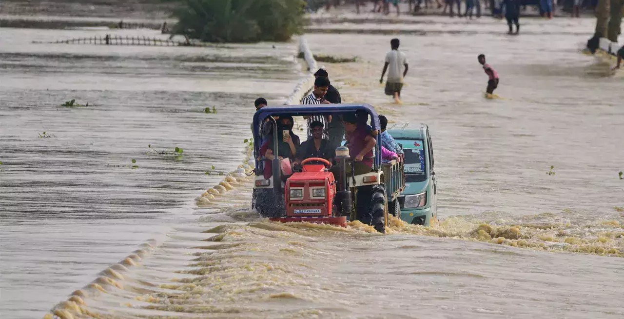
Kerala is once again in the news for an extreme weather event, as its Wayanad district reels from destruction wreaked by one of the most devastating landslides triggered by incessant Monsoon rains. During the wee hours of July 30, multiple landlines swept away several villages in the district. The tragedy has claimed over 100 lives and injured several.
Kerala receives the second-highest monsoon rainfall in India after its northeastern states. It records an average annual rainfall of about 3,107 mm of which 75% is received during the monsoon months of June-September (JJAS).
Geographically, Kerala is bounded by Arabian Sea to its west and the Western Ghats to its east. This makes it highly susceptible for heavy rains during the season. Orography has a strong effect on rainfall distribution in the mountainous region of Kerala. The rainfall potential of the region increases from the coastal belt towards the Western Ghats, reaching a maximum on the windward side of the Ghats and rapidly decreases on the leeward side.
The rainfall characteristics over Kerala are unique because of the influence of isolated steep-sloped structures separated by the wide Palghat gap.
Contrary to this climatology, the state has experienced severe floods in recent times due to intense precipitation during the SW monsoon. However, experts suggest that factors beyond the meteorological factors, such as climate change and unplanned development, are to blame for the catastrophic landslides.
“Whilst rainfall in Kannur district has been 21% above the average between 1 June and 30 July, it is 14% below the average in the neighbouring district of Wayanad, and up to 25% below average in Idukki and Ernakulam districts. The co-occurence of two extreme scenarios (landslides and rainfall deficit) in the same state reflect a strong spatial variability in this year’s monsoon rainfall. The expectation is that such a pattern would become more intense in the future if global warming continues,” said Dr Akshay Deoras, Research Scientist, National Centre for Atmospheric Science and the Department of Meteorology, University of Reading, UK.
There has been a steady rise in extreme events in the state over the last decade. For example, Cyclone Ockhi wreaked havoc in 2017, followed by devastating floods in 2018, which were among the worst in the state's history. In August 2019, the state experienced another spell of extremely heavy rainfall.
According to a report, ‘Climate Change Assessment over the Indian Region’, the interannual variability of summer monsoon rainfall is projected to increase throughout the twenty-first century. The increased frequency of localised heavy rainfall on sub-daily and daily timescales has enhanced flood risks across India.
Role of Climate Change and the science behind it
Numerous studies have established that the rise in global average temperatures due to human-induced climate change has led to an increase in the number of extreme rainfall events (ERE) associated with monsoon, thunderstorms and short-spanned local cloudbursts. These events, ranging from a few hours to a few days, have become more frequent in the recent decades over the subcontinent.
The effects of climate change have led to changes in monsoon trends due to the weakening of synoptic activity within the Indian monsoon and the moistening of the tropical troposphere. The meteorological factors behind extremely heavy rainfall include:
“Climate change is drastically changing rainfall patterns in Wayanad. What was once a cool, humid environment with year-round drizzles and monsoon rains, is turning into one marked by drier, hotter summers and intense downpours during the monsoons. This change has increased the risk of landslides. Dry soils absorb less water and heavy rainfalls cause run-offs that can lead to landslides, such as the ones we've seen this week,” said Mariam Zachariah, Research Associate, at Imperial College London.
Citing similar views, Mahesh Palawat, Vice President of meteorology and Climate Change, at Skymet Weather said, “Monsoon patterns have definitely changed and they now behave erratically. Earlier during the Monsoon season, we used to witness uniform rains and no convective activity, but now we see rains which are more of pre-monsoon characteristics that include thundershowers. Kerala has not been witnessing typical Monsoon rains and has been struggling to achieve its average rainfall. Despite these heavy showers, it is yet to surpass its average rainfall so far. Also, with the rise in air as well as ocean temperatures, there has been a drastic increase in moisture. The Arabian Sea has been warming at a faster rate, pumping moisture into the atmosphere, and making it unstable. All these factors are directly linked to global warming.”
Over 90% of global warming is observed by oceans, which has led to a significant rise in ocean heating. As per new research by Nature, oceans have warmed by more than 1.5 °C since the beginning of the industrial era, challenging previous estimates. The Indian Ocean is a hotspot for climate change and has seen the fastest surface warming since the 1950s. This rapid warming of the Indian Ocean has led to an increase in marine heat waves, which impact the monsoon by reducing the rainfall over the central Indian subcontinent while enhancing it over the southern peninsula.
The cumulative rainfall for Kerala from June 1 to July 30 stands at 1,222.5 mm against the normal average of 1,283.5, resulting in a deficit of -5%. According to meteorological criteria for districts during monsoon, a departure of +/-19% is considered to be normal rainfall.
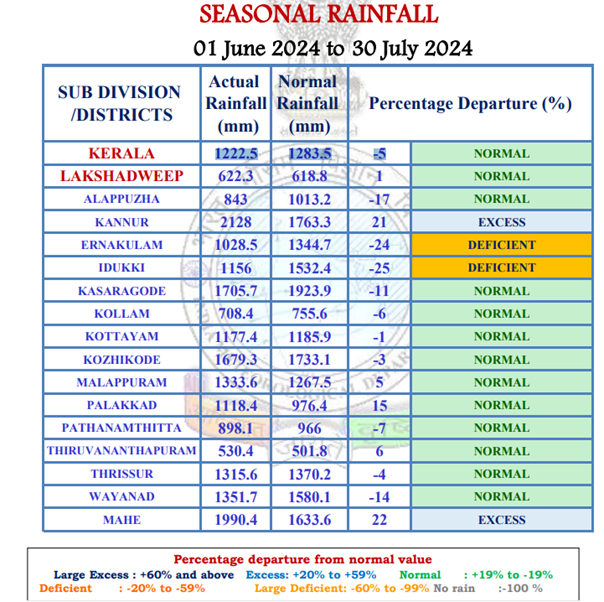
Data Source: IMD
According to the report ‘A review on the extreme rainfall studies in India,’ the frequency and intensity of extreme monsoon downpours in India have increased over the past 50 years, despite significant inter-annual variability.
Trends indicate that extreme rainfall events are likely to continue increasing in the coming decades. The intensification of extreme sub-daily rainfall is driven by convective feedback and changes in regional circulation, as temperatures exceed Clausius-Clapeyron scaling in both localized and larger regions.
The number of heavy rainfall events is increasing, while the number of rainy days during the monsoon is decreasing. Contributing factors include the variability of low-level monsoon westerlies over the Arabian Sea, which drive surges of moisture supply, the trailing strength of monsoon circulation, and the variation of vertical wind shear from the break phase to the active phase of an Indian Summer Monsoon (ISM) cycle.
A few studies have also suggested that changing climate, increased monsoon flow strength in the last two decades, and human-modified land cover changes have contributed to the increased frequency of Heavy Rainfall Events (HRE).
Role of Unplanned Development
Deforestation, rapid urbanization, unplanned development, and poor planning are significant factors exacerbating the climate crisis in India. Development plans and human interference are not complementing the ecological balance of the mountainous terrain.
“Construction of roads should be done with all scientific techniques. At present, we just see roads being made or widened without taking proper measures such as no slope stability, lack of good quality retaining walls, and rock bolting. All these measures can restrict the damage done by landslides up to some extent. There is a huge gap between planning and implementation. For instance, rainfall patterns are changing, temperatures have been increasing along with extreme weather events. Policymakers should be well-versed in the geology of the region. There is no denying the fact of development but hydropower plants, especially in higher Himalayas should be of less capacity. Policy and project implementation should consist of local geologists who understand the terrain well and how it responds,” said Professor Y P Sundriyal, Head of Department, Geology, HNB Garhwal University.
The Western Ghats have been classified as an ecologically fragile region. According to recent research by the Indian Institute of Science, the 1.6 lakh sq km of hats in six states have been divided into four ecologically sensitive regions (ESR): very high ecological fragility (63,148 sq km), high ecological fragility (27,646 sq km), moderate ecological fragility (48,490 sq km) and low ecological fragility (20,716 sq km).
Roxy Mathew Koll, Climate Scientist, Indian Institute of Tropical Meteorology (IITM), Pune called for early warning systems to curtail the damage from natural disasters, “Roughly half of Kerala are hills and mountainous regions where the slope is more than 20 degrees and hence these places are prone to landslides when heavy rains occur. Landslide-prone areas are mapped and available for Kerala. Panchayats with hazardous areas should be identified and sensitized. We need to monitor rainfall data in these hotspots and prepare early warning systems targeted at hazard-prone areas. This is possible with the current technology and know-how and could save lives and livelihoods. Other than climate change, we also need to evaluate the land use changes and development activities happening in landslide-prone areas. Often landslides and flash floods occur over regions where the impact of both climate change and direct human intervention in terms of land use changes are evident. At the same time, there have been many severe landslides over regions with minimal land use changes also.”
“The devastating landslides in Wayanad, a direct consequence of excessive monsoon rains, highlight the urgent need to address climate change. Kerala has been increasingly hit by such events, which are closely linked with global warming and consequent climate change as a significant factor behind the irregular, heavy rainfall patterns. Several measures can be taken to mitigate the impact of landslides and excessive rains linked to climate change. Implementing robust early warning systems through enhanced weather forecasting technologies can provide timely alerts about heavy rainfall and potential landslides, enabling residents to evacuate and prepare. Strengthening infrastructure by investing in climate-resilient bridges and roads will help withstand extreme weather events and facilitate quicker rescue operations. Promoting sustainable land management is also crucial; practices such as reforestation, controlled deforestation, and sustainable agriculture can maintain hillside stability and reduce soil erosion, thereby lessening the effects of heavy rains,” said Prof Anjal Prakash, Clinical Associate Professor (Research) and Research Director, Bharti Institute of Public Policy, Indian School of Business and IPPC Author.
“Landslides caused due to heavy rainfall are an overlooked disaster in India despite killing hundreds of people every year. Changes in land use can increase their possibility, especially in the backdrop of increasing extreme rainfall events due to global warming. It is therefore important that the monitoring and prediction of landslides in the country is put on a high priority,” added Dr Deoras.
The Western Ghats are one of 36 global biodiversity hotspots, with forests in this region sequestering atmospheric carbon, thereby aiding in moderating the global climate and sustaining water and food security in peninsular India. An assessment of land-use land-cover (LULC) dynamics using temporal remote sensing data shows a 5% decline in evergreen forests accompanied by an increase in agriculture, plantations, and built-up areas. Intact forests have declined by 10%, and are now largely confined to protected areas. Simulations of future changes indicate that the region will have only 10% evergreen cover, 17% agriculture, 40% plantations, and 5% built-up areas.
The Western Ghats of Karnataka represent the highest forest cover (37.4%), followed by Maharashtra (25.9%), Kerala (17%), Tamil Nadu (13.6%), Gujarat (3.9%) and Goa (2%). \Historically, from 1920 to 2013, the Western Ghats in Kerala experienced the highest forest cover loss, with a 62.7% reduction in forested area.
The recent floods in Wayanad serve as a critical reminder of the urgent need to address climate change and its devastating effects on vulnerable regions. As extreme weather events become increasingly frequent, it is essential to implement effective mitigation strategies, including robust early warning systems and sustainable land management practices. By prioritizing climate-resilient infrastructure and responsible development, we can better protect communities from the catastrophic impacts of future disasters, ensuring a safer environment for all.
Wayanad Floods Climate Change Extreme Weather Unplanned Development